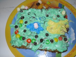
Can you find the marshmallow glacier in this picture?
Ever since we started school a few weeks ago the kids have been asking about when we’ll make Cookie Dough Maps. I tried this last year when we studied ancient Egypt, as an alternative to the “Let’s-keep-it-forever-mom!” salt dough maps. Little did I know I was starting a tradition.
A tradition that is not, let’s be honest, for the health-conscious mom.
Oh, well, I’d like to be remembered as “cool mom” instead. This project qualifies!
In order to get a platform large enough to do anything, I had to make what was supposed to be 48 cookies. Each child got almost 1/4 of the recipe (with a little bit cut off the sides for mom and dad!). This was math they enjoyed doing….how many cookies will you get if you eat 1/4 of 48? Suffice it to say, they weren’t allowed to eat it all in one sitting!
Last year we tried making a country-specific map of Egypt. This year we’ve been reviewing geography terms, so I told them that their map could be whatever they wanted it to be (a real place or make-believe) but that it had to show several geographical features, such as rivers, oceans, mountains, etc. My 9 year old enjoyed making several “knobs” out of mini marshmallows (a knob is bigger than a knoll, by the way, but smaller than a hill, which is smaller than a mountain…)
To keep it simple, I purchased ready-made chocolate chip cookie dough at the store (2 packages) and pressed it out into a large square baking dish. When the cookie bars were finished, I cut out large squares and carefully gave one to each child on a plate. They were also given bowls of colored frosting (yellow for sand, blue for water, green for grass) and a couple of squirt bottles of frosting.
We used M&M’s, mini marshmallows, and chocolate chips for land features. One child used frosting to stack marshmallows into a large mountain, while another heaped up candy underneath blue frosting to simulate water running down both sides of a mountain.
These maps may not look too realistic, but they served their purpose. We tossed around a lot of geographical terms, and the kids were motivated to incorporate as many geographical elements as possible into their maps, if only to get more candy on there. A mere island wouldn’t do when an archipelago requires so much more candy!
This project is a bit like a three-year-old’s drawing: you probably won’t be able to tell what anything represents, but the child will know it exactly! My children were required to point out every geographical feature on their map, by name, to prove that they weren’t just putting candy onto cookies. Is this how cartographers get started?
7 year old’s comment: “This is 3,000 calories worth of map”.

Excellent!!!